


The Touristic Info Halkidiki informs - Hiking on Halkidiki -
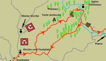
Chalkidiki - Vrastrama to the church of Agios Efthymios
This walk is quite arduous and difficult in places requiring good footwear, and should not be attempted after heavy rainfall. The walk Starts in the high mountain village of Vrastama and follows an unsurfaced road over the hill behind the village to descend along a narrow ridge into the large valley beyond. The many deep ravines cutting through the valley restrict the possibilities for easy progress and it is necessary in places to descend into the beds of streams and follow watercourses.
The highlight of the walk is a visit to a natural cave, Ag. Efthymios at the bottom of a remote ravine. This was once the home of a hermit, and is now a shrine.
The route
There are two possibilities for this walk. The first is a one-way journey from Vrastama to Ag. Efthymios and then on to the road near the village of Plana. This has the advantage that one does not have to re-ascend out of the ravine, but the disadvantage that transport will need to be arranged for the return to Vrastama. The second possibility is to visit Ag. Efthymios and then return to Vrastrama by following a different route back; which makes use of goat trails to climb through the bush.
The start of the walk is the road junction opposite the school in Vrastama. Follow the road, which rises to the west directly opposite the school. In a couple of hundred metres a junction is reached with a water trough on ground to the left. Take the right fork, which leads past a large red Eklissaki up to the beautiful little church, with its fountain and picnic tables. To continue follow the road leading east and up the hill, with the church on your left side. This track quickly gains height and provides beautiful panoramic views of the countryside to the right.
After half a kilometre or so the track bears right, past another church to reach a junction. Turn left here onto a new track (signposted Ag. Efthymios) which breasts the ridge to descend into the large valley down one of the many small ridges that radial down the valley's length. Magnificent views are to be had from here of the whole valley ahead and to the left. The town nestling high on the hillside to the north is Taxiarhis . Directly ahead, in the distance, can be seen a plateau of land linked to the end of the ridge that we are descending. After one kilometre of easy walking the path bears right and then left to approach this table top of land.
The route passes through an olive grove, and then climbs to the highest point, where it comes to a sudden end, with steep wooded cliffs on three sides. The way forward is indicated by another signpost to Ag. Efthymios, which points to, a small track descending the steep cliff face to the east. This narrow, but good, track zigzags down into the ravine. As the bottom is approached a large white wooden cross can be seen high on the opposite cliff ahead. This marks the position of the shrine, which we are approaching. Soon the path arrives in an open space at the bottom of the ravine. Makeshift tables and benches are provided, in this lonely spot for feast days, making it a good spot for lunch. To visit the grotto of Ag. Efthymios cross the bridge and walk along the left side of the stream for about 60m, where a narrow path will be seen climbing up to the left. This leads directly to the cave, which is accessed by wooden Steps. Return to the stream by the same route. From here there are two options:
1. to carry on to reach the road leading to Plana (Only do this if you have arranged transport at the other end)
2. to return to Vrastama
1. To continue to Plana, follow the left hand bank of the stream in the direction it is flowing. At the bend cross the stream and follow the path on the right hand side, which may involve scrambling over some of the large rocks in the stream. After 200m or so the stream bends sharp left, where there is a wall ahead, directly under the rock face. Depending on the depth of water, walk either along the wall or along the streambed. Follow the left bank of the stream for a distance of about 100m, whilst looking for a narrow track, which rises to the left. Look for the way marker sign on a tree. Ascend this path, which rises up from the stream but continues to follow it for a while. Keep left at the junction, which is reached in about 100m. The path now enters an olive grove and crosses the southern edge to arrive at a large tree in the top right hand corner. The path has now become a farm track and meanders up and down in an Ag. Efthymios southeasterly direction for a further 500m, when a track joins from the left on a curve. Keep on the main track, which continues its gradual descent down the side of the valley for a further 300m. to arrive at a junction. Here turn sharp left onto the smaller track, which leads to an orchard in about 70m. Turn sharp right here to find a small track which descends a slope then winds its way along below the orchard, where the flora and fauna are much more interesting. After 200m this path reaches an open cultivated area. Pass round the bottom edge of the garden and follow the right side up to a field, across which is a freshwater spring, with a cup hanging from a pole. One hundred metres further on the path becomes a broad sandy track, which is followed to a junction with a thorn bush at its centre. Keep left here and then, in 50m, keep right at the next junction. The track now meanders up and down gradually gaining height for a further 350m to arrive at another junction.
Here take the lower path, which descends to the right, bringing you in a further half kilometre to an olive grove. Carry on, due east, straight across the top end of the grove, and through the middle of the next grove. The track continues on to arrive at a church with roofed picnic tables and fiesta area. This is a fine place to stop for refreshment and the church is well worth visiting. The path now descends to the west of the church and then swings sharply round to the south, passing beneath it. Three hundred metres further on young olive trees are passed as the path bears right towards a small building. Turn right at the tree and then left at the next building, which has a stream flowing through a tunnel in its wall. Ahead there is a large stone to the left and a large tree in front. The path turns left at the tree and follows the stream. To the right is the stream with a high earth bank on the opposite side. A little further on the track fords the stream. To keep your feet dry in wet weather, cross by the large stones to the left of the ford. The track now rises to the right away from the stream only to meet it again 200m further on, with an impressive clay cliff face on the opposite side. Here bear right and cross the ford, then follow the track for a further300m, at which point the stream passes through a tunnel in a very large embankment. The track climbs to the left up this embankment. Descend the other side and follow the track past a pig farm and on down the valley for a further 2km. In the last 300m it is necessary to ford the stream again to eventually emerge on the unsurfaced road leading to Plana. Here your transport back to Vrastama should be waiting, if you have pre-booked it.
2. To return to Vrastama from Ag. Efthymios. Take the route downstream towards Plana as far as point A on the map, where the path to Plana climbs away from the streambed. Directly opposite this point is a similar path climbing up the right-hand bank, past large trees and through a gap between two sections of rock face. This is an ancient mule track and in places parts of the original stone road can be seen. Follow this route as it climbs, through dense bush, due south out of the gorge. In about 400m the path Swings towards the west and emerges into open ground. The route now leads west to re-enter the bush in about 40m (look for the way marker). In a further 360m a large tree is reached with a small stream just beyond it. There should be a Poseidon symbol nailed to the tree. This indicates the start of a narrow goat track, climbing up through the bush, immediately behind the tree. Follow this track, which meanders up through dense bush land for about 300m to emerge into the corner of a large open field.
Follow the hedge on the left, the south side, in order to ascend the hill to the top of the field. Here there is a smaller field with a broad mountain track beyond, which ascends to the top of the ridge. Cross the field onto the track but, before continuing, look back for a panoramic view over the whole valley.
Now continue up the track for a distance of 1200m to attain the ridge. From here turn right and follow the track back down towards Vrastama. After 300m or so the junction is reached with an Eklissaki, where you turned off for Ag. Efthymios, earlier in the day. Continue on, down the main track back to Vrastama.
Service
All Hiking Tours you can be printed out in the office of the Holidays and more tourist info in Psakoudia. If you want to use a navigation device to support the hikes, please contact us one day in advance at the office of the Holidays and more tourist info. You will then receive your Desired issue a navigation device to your personal walk for a small fee.
We wish you have fun when you walk through the beautiful Chalkidiki!

Your rental car in Halkidiki
From the airport Thessaloniki, Hotel, Apartment and Studio in whole Chalkidiki. No credit card needed. Fast, easy and safe. For 3 days only from 63.- € !