


The Touristic Info Halkidiki informs - Hiking on Halkidiki -
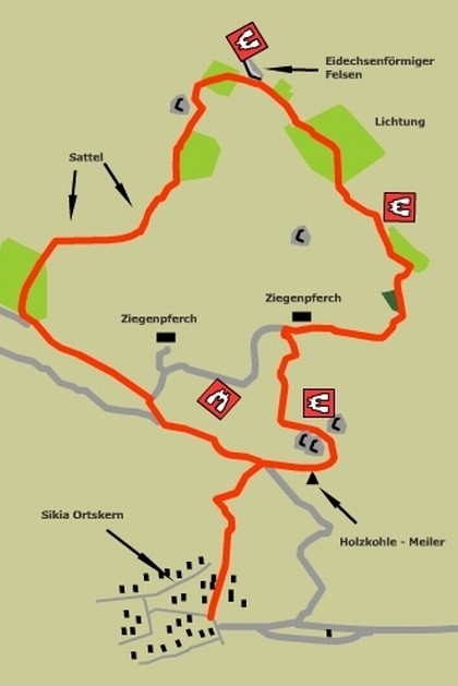
Sithonia - Sykia - circular track
This walk takes one on a circular trip around the ridge directly above the town to the north, giving fine views over the town and the surrounding countryside. The route makes use of old charcoal burners paths, goat tracks and unsurfaced farm access roads. Parts of the circuit involve rather steep, but safe, rocky ascents and descents.
Time required: 4 hours.
The route
The Sykians have a long standing tradition of independence and an unwillingness to be subdued.
Park on the outskirts of the village, just before the one-way street leading to the centre. A tavern straddles the space between the access and exit roads from the village centre. From here walk along the one-way street towards the centre, with a streambed to the right.
From the Plaza look for the Poseidon way marker signs, which follow the street to the northeast. At the end of the street a track continues up the hillside in a north-easterly direction, to emerge on a broad dirt road in a distance of 1 km. Cross over the road and look here for a red Poseidon sign, in spray paint, on the rock face. This marks the start of a small rocky track that rises up the cliff face to eventually reach the summit above us.
Follow this track, which leads up to a circular grassy area in 120m or so. This is an old charcoal burner's workplace*.
In former times this hill would be covered by woodland, which was felled to produce charcoal, leaving the scrubland, which we see today. The path leads on, climbing up and round the end of a large rocky outcrop. It then turns northwest, leading straight up the slope, as it winds its way between, and sometimes up and over, magnificent, smooth, rounded rocks. It then turns north through a narrow col to arrive at the first summit. From here there are excellent views towards the coast and of the town and countryside below.
From the top of the hill, goat pens can be seen to the north in the valley below. Beyond is an encircling ridge, which is our next goal. Follow the goat tracks down the minor ridge, which leads towards the pens (the best route should be marked with red and white tape on the bushes or red paint on the rocks). In 500m a streambed is crossed and the path rises to the goat pens. Walk along the farm track, which leads due east through the pens, to reach a small promontory; looking down onto a stream below.
Ahead, across the stream, are two olive trees that mark the path up the hill. Cross the stream and join the path, which climbs steeply to the east, then Swings to the west, gaining 50m or so in height, to arrive at an old olive grove. The route passes through the small grove, and then swings east towards a large rock face. Pass directly below and round to the right of the very large rock to arrive at a large field. Follow the left hand edge of the field past a large, weather carved rock to reach a second summit, at approximately 280m above sea level. This is another fine viewpoint.
Now follow the good rocky track leading northwest along the ridge, which arrives at yet another high-level field in a further 400m. Cross this field, passing a large rock to your left, and climb west towards a lone tree.
Continue on towards the ridge in front and, as the field is left behind, the ground drops away into the valley on your left. Continue round the head of the valley, gradually climbing in a northwesterly direction, and enjoy the fine views in all directions. As you continue a grassy ridge appears ahead and to your right. Make for this ridge to see over into the next valley. A large inclined rock, shaped like a lizard's head, with a small grassy area to the right, is seen next. Climb up to this rock for magnificent views of the sea to the east and the valley that lies beneath us. This rock at 345m is the highest point on the route.
Continue west, descending to a field about 70m away, then turn left into another field 40m to the south. Here turn right, descending to the bottom of a small dip and rising up the other side.
At the edge of the field continue on along the goat track to the neck of the valley, cross the stream and climb straight up the other side. Here a maze of goat tracks head south as they traverse around the corner, to the left of a very large rock, in order to access the next small field. The best track should be marked with red paint on the rocks and plastic tape on the bushes. Skirt round the top of the field to exit by a path at the top right hand corner. This leads up to a small col, which is crossed to continue southwest around the head of the valley, providing superb views to the east.
The track now descends gradually for about 300m, before rising on an excellent path to the top of the next col. From here descend towards the goat pens in the valley below for 1 50m or so, when a field appears to the left. Cross the top of this field to arrive at another field containing beehives.
Directly ahead, across the second field, is a dirt track, rising to the brow of the hill. Cross the field to reach the track at its highest point. The return route follows this track down to the southeast, and back towards Sykia.
After 700m of descent a track joins from the left. Turn right onto this track and continue down to pass a rock, which has been sculpted by the weather to look like a human face. A further 350m of steep descent bring us to a bigger road from the right. Turn left onto this road and continue down, to reach the old track leading back down to point A on the map. From here retrace your Steps back down to the village and a welcoming tavern.
*Many years ago it was a common site to see the Charcoal burners at work in the forests of Europe . Today the only evidence of this once widespread occupation are the flat circular hearths, where the fires were built, and the occasional stone built bread oven. However this ancient craft is still practised in Halkidiki.
Near Taxiarhis in the Holomondas mountains l came across wood stacked ready for converting to charcoal.
The fire is lit and then covering the stack with wet earth to reduce the oxygen supply slows the burning right down. While burning the fire must be watched night and day to ensure a good yield of charcoal. When the fire breaks out at any point it must be quickly sealed in again with wet earth. After several days the fire goes out and the earth cover is removed to reveal a Stack of lump wood charcoal.
Service
All Hiking Tours can be printed out in the office of the Holidays and more tourist info in Psakoudia. If you want to use a navigation device to support the hikes, please contact us one day in advance at the office of the Holidays and more tourist info. You will then receive your Desired issue, a navigation device to your personal walk for a small fee.
We wish you have fun when you walk through the beautiful Chalkidiki!

Your rental car in Halkidiki
From the airport Thessaloniki, Hotel, Apartment and Studio in whole Chalkidiki. No credit card needed. Fast, easy and safe. For 3 days only from 63.- € !