The Touristic Info Halkidiki informs - Hiking on Halkidiki -
Sithonia - Neos Marmaras to Parthenonas and back
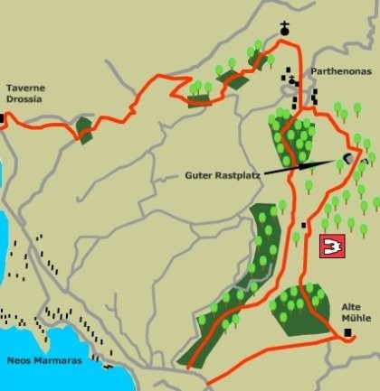
This long walk visits the very old village of Parthenonas and the walker is given two alternative methods of ascent and descent, depending on one's abilities. One can ascend by a beautiful, if strenuous route, which visits an old water mill and dam and then climbs straight up a ridge, through olive groves and forest, to reach high forest tracks, leading to the village. Alternatively one can ascend from the tavern 'Drossia' via easy forest roads.
The descent can be by either of the above routes or a much shorter, steep route, which follows a mountain streambed. (4 hours).
The route
Parthenonas dates back to the days of the pirates when the inhabitants lived in the hills away from such danger. The village stands at a height of 300m and the difficulty of living there in modern times caused the whole population to abandon it in 1970, and move down en-masse into Neos Marmaras, where the living was easier. However, since then many of the houses are now being renovated, as wealthier people move back for the fine views, peace and solitude.
Option A:
Strenuous direct ascent, including the visit to an old watermill. The walk Starts on the Neos Marmaras bypass directly opposite the southern access road into the village, the Porto Carras end.
At the start, look for the way marker marking a farm access track directly opposite the southern access to Neos Marmaras. This track descends from the road and continues in a northeasterly direction, for 600m or so, to arrive at a farm, with cattle and pigs. Further on beehives are passed. About here we leave the farm track, joining a smaller path to the right, which continues, towards the head of the valley. Soon a streambed is crossed, and then crossed again, as the route bears round towards the south. The path now follows the left bank of the stream for 200m, to arrive at an abandoned mill. Although it only dates back to the 1920's this building is worth investigating. A path to the left of the building leads up and behind it to a large water storage tank. A 160m long stone aqueduct, which can be followed up the valley to the dam and reservoir, feeds this tank. To continue to Parthenonas we retrace our steps from the mill for 60m. Here turn right, at a large olive tree, onto a path, which climbs the ridge on which the olive grove stands. The route continues upwards for more than a kilometre, negotiating the stepped levels of the olive grove.
As you climb take time to enjoy the view of Kelyfos Island to the rear, the fine olive groves to the left and the deep gorge that drops away to your right. Eventually the olive grove is left behind and the path passes through scrubland and. forest, meandering somewhat, but maintaining its line up the ridge. At the top of a rise, a farm is seen ahead. The path now swings due north to avoid the farm, and turns on to a farm track. This track travels northeast through open woodland and across a narrow ridge, with a gorge on both sides. As you cross the ridge look for two large stones at the left of the track. The path leaves the farm road here to continue its journey to the head of the valley. The way now passes through a small canyon, beyond which is a flat piece of ground surrounded by large rocks; a fine place for a coffee break.
The next part of the route exits at the north end of the Clearing, descending to the northeast, where a flat bed of rock marks the head of the valley. The track now climbs slightly, passing under a large tree and round a large rock. Below and to the left look for a grassy forest track. Drop down onto this track, which follows the hillside round towards the northwest for a kilometre or so, to arrive at an isolated house with beehives. Soon Parthenonas can be seen ahead as the last 600m of path leads us first down and then up to the plateau on which the village Stands.
Option B:
Easy The start for this walk is the tavern Drossia, which is on the left as you approach Neos Marmaras from the north, about 1.5km from the village. Walk up behind the tavern onto a track, which rises to the left, through a small grove of olives, to meet another track. Join this track, which climbs up, behind the houses and passes some beehives. Keep left at the junction as the track ascends. Continue on the main track, which meanders up in a northeasterly direction; keeping to the left at the next two intersections. The terrain alternates between olive groves and mixed woodlands and is particularly beautiful in autumn. At the next junction keep left through the olive grove and continue, contouring round the side of a deep valley on the right, to arrive at the next fork. Here take the smaller track to the left and continue on through an olive grove on a broad, flat plateau of land for 200m or so, when the path begins to climb again. At the next junction follow the lower road to the right, as the road to the left is just an access road for a small church on the hillside above. From here one gets a good view across the valley to Parthenonas and one can see how its position, high in the hills, would dissuade pirates and other marauders from venturing up there. The track continues to ascend to the northeast, then turns right at the head of the valley to ford a stream and travel southeast into Parthenonas, past a row of houses. There are two taverns in Parthenonas, one at each end of the village. Just over the road from the Village Hall, near a large tree, is a small distillery that makes Tsipouro the local Greek firewater.
Direct Descent:
This steep but safe descent brings one out on the Neos Marmaras road near the Start of the strenuous route, described earlier.
From the southern end of Parthenonas, follow the Poseidon signs south, directly down through the olive groves to the streambed. Here a goat track is followed parallel to the streambed for about 1 km, at which point the path crosses the stream into the olive grove on the other side. The route now descends through the olive grove to arrive at the main road only 300m north of the Start point.
Service
All Hiking Tours can be printed out in the office of the Holidays and more tourist info in Psakoudia. If you want to use a navigation device to support the hikes, please contact us one day in advance at the office of the Holidays and more tourist info. You will then receive your Desired issue, a navigation device to your personal walk for a small fee.
We wish you have fun when you walk through the beautiful Chalkidiki!


Your rental car in Halkidiki
From the airport Thessaloniki, Hotel, Apartment and Studio in whole Chalkidiki. No credit card needed. Fast, easy and safe. For 3 days only from 63.- € !


