The Touristic Info Halkidiki informs - Hiking on Halkidiki -
Kassandra - Hanioti Firetower
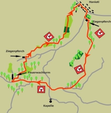
This path takes one from Hanioti on the east coast of Kassandra up onto the long ridge, which is the backbone of the peninsula. It then follows this ridge north to the fire lookout tower, situated at one of the highest points on the ridge, before descending again to Hanioti.
The climb follows goat tracks up a minor ridge from Hanioti to reach the main ridge, which gives expansive views in all directions of the surrounding terrain. A wide forest track is followed along the middle section revealing fine views of Skioni and the western coastline and, on the descent to Hanioti, the eastern coast lies before us.
The route
Start: From the centre of Hanioti follow the main road south for 200m and then turn right onto the road to Nea Skioni. 600m up this road, soon after passing a sign advertising the Hotel Hilltop, there is an open area ahead on the left, with a fountain and children's park. Look for Steps moulded in to the side of the dry concrete water channel and cross to the other side. As the recreation area is reached turn left up the small track with a fenced olive grove on the left and a goat shelter on the right. At the end of the goat shelter bear right onto a sandy track, which climbs up onto a minor ridge leading south. As you gain height, passing a large rock on your left, look back for a fine view of the coast Sithonia, Kelyfos Island and Mount Athos beyond. The route eventually becomes more wooded, as it meanders up and down along the ridge to arrive at a dirt track in a further 600m or so. Look for the continuation of the route on the opposite side of this track, about 15m to the left. The ascent continues up a dry streambed, which leads southwards and upwards, to emerge onto a broad forest road in a further 200m. Turn right onto this road and follow it for 200m. Here it is possible to leave the road and bear off to the left up a goat track. This gives a further 300m of interesting walking before it drops down once more to rejoin the forest road. Now follow this forest road for 300m, to its intersection with the main track traversing the backbone of Kassandra. Here turn right for the second leg of the journey, which leads along this broad track for 250m, at which point if crosses the road between Hanioti and Nea Skioni. The track continues in a northwesterly direction and is an ideal platform from which to view the west coast of the peninsula. The fire tower is reached after 2km of easy walking along this track. Take the wide access track, which winds up to the tower from a point on the main track just below it.
The descent back to Hanioti passes through the field directly north of the tower to emerge into a smaller field. Follow the right band edge of the field to arrive at another forest track. Turn right onto this track, with a wood to the left. At the end of the wood turn left down the ridge onto a track leading to a field. Continue down, past young olives to the right, along this fine grassy ridge, towards an outcrop of rock ahead. Take the path to the left of the outcrop to arrive in another large field. Follow the left-hand edge of this field first southeast and then northwest as it turns to descend into a smaller field. At the bottom of the smaller field the path continues northwest as it descends very steeply through dense brush on a goat track. The route gradually swings round to the north to arrive in a dry streambed, about 500m after leaving the ridge. A short climb up the bank on the opposite side of the streambed brings one to a broad mountain road. Turn left onto the road and walk 100m or so up the road to a junction with a traditional brushwood goat shelter set in the V of the fork. Climb up past the right hand side of this shelter and follow the goat track up onto the next ridge. After half a kilometre of generally gentle ascent the dense brush gives way to more open country. The route now continues along the ridge in an easterly direction for a further 800m to emerge into a succession of cornfields, and the occasional olive grove, linked by a narrow track that follows the ridgeline. Follow the route markers to avoid trampling the crop when the field is sown. A further 1700m of gradual descent brings us to a large concrete water reservoir with cabin on top, complete with radio mast. From here the route descends to the village, through a grove of large pine trees, to a crossroads in the wood. Turn right here, keep left at the next junction and follow the track down to the main road in Hanioti, which is reached in a distance of 800m from the reservoir. Turn right along the road for the village centre.
Service
All Hiking Tours you can printout in the office of the Holidays and more tourist info in Psakoudia. If you want to use a navigation device to support the hikes, please contact us one day in advance at the office of the Holidays and more tourist info. You will then receive your Desired issue, a navigation device to your personal walk for a small fee.
We wish you have fun when you walk through the beautiful Chalkidiki!


Your rental car in Halkidiki
From the airport Thessaloniki, Hotel, Apartment and Studio in whole Chalkidiki. No credit card needed. Fast, easy and safe. For 3 days only from 63.- € !


